티스토리 뷰
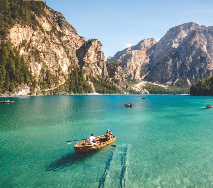
01-Great Barrier Reef

History of The Great Barrier Reef
The early European explorers of the Great Barrier Reef faced huge difficulties as they battled wind, strong currents and tides in an ocean riddled with dangerous reefs and sand bars. The first European to record the existence of the Great Barrier Reef was Louis de Bouganville in 1768, though he did not claim the area for France.
In 1770, Captain James Cook ran aground at the aptly named Cape Tribulation while exploring and charting the Reef, but it was not until the early 20th Century that serious thought was given to the study, preservation and use of the Reef as a national Australian treasure.
Today, The Great Barrier Reef falls under the control of the Great Barrier Reef Marine Authority and the Environmental Protection and Biodiversity Conservation Act passed by the Australian Federal Parliament in 1999.
Geography of The Great Barrier Reef
The Great Barrier Reef follows the continental shelf down the East Coast, and is made up of many separate reefs interspersed with the occasional island and deep channels used by shipping.
It is a complex area and one that requires local knowledge and skill to navigate safely. There are many different access points to the Reef, the main one being Cairns for access to the northern Reef, Lizard Island and the Daintree Rainforest Area.
Hamilton Island is the main airport access area to the Whitsundays and Bundaberg is the entry to the southern Reef, Lady Elliot Island and Heron Island. The Great Barrier Reef ends north of Brisbane, the Sunshine Coast and Fraser Island.
The Satellite image of the Great Barrier Reef on the left covers The Great Barrier Reef’s 2,600 Kilometre (1,600mi) length, from Cape York in the north, to Bundaberg in the south. The Whitsundays, Hamilton Island and Airlie Beach are in the middle of the Satellite view.
02-Ayers Rock

Nothing has quite prepared you for the contrast between the red sand stretching to the horizon in every direction and the monolith of red rock jutting upwards like the toe of a sleeping giant sticking up through the desert.
It is sometimes hard to reconcile your pre-conceived notions with reality as you land into Uluru (Ayers Rock).
Uluru (Ayers Rock) is a mystical place, one to be savoured as the sun rises and the Rock changes colour to meet the new day, or at sunset as the last rays beam across the flat of the desert and highlight the crevices and fissures of Uluru as it settles in for the night. It is almost as if this Australian Icon has a personality of its own.
History of Uluru (Ayers Rock)
The Aboriginal People of Australia lived around Uluru Ayers Rock for over 30,000 years before 1873 when William Gosse, a surveyor, first recorded its presence for the new European settlers of Australia. He named it Ayers Rock after the Chief Secretary of South Australia, though it is now officially known as Uluru Ayers Rock to honour the original Aboriginal name as part of a dual naming policy.Uluru Ayers Rock and the nearby Kata Tjuta have great religious and spiritual significance to the local Anangu people and are the subject of many tales and myths handed down through their Aboriginal Dreamtime stories. Tours of Uluru Ayers Rock, either walking, vehicle based or by camel will get you up close to the Rock at almost any time of day.
Geography
Uluru (Ayers Rock) is located in the geographic heart of Australia, about 3 hours flight from the main cities of the east coast or south of Australia – it is almost equal flying time from Sydney, Cairns, Melbourne or Adelaide.The Rock itself is made up of sandstone with oxidation of iron bearing minerals in its makeup giving it the distinctive red colour for which it is famous. Perhaps the best way to get a feel for the size and scale of Uluru Ayers Rock is to see it up close from the air on a Helicopter Tour.
Weather and Climate at Uluru (Ayers Rock)
You will be in the middle of a continent, in the middle of one of the greatest expanses of desert in the world. It will be very hot during the day in Summer and can be cold overnight in Winter.I will list the average daytime highs and overnight low temperatures for each month to help your decision making on the best time to visit. You also need to be aware that there will be more annoying black flies trying to get into your nose and mouth than you thought possible from December to end April. It is wise to purchase a hat with netting on it while you are there.
03-Great Ocean Road

The Great Ocean Road today is one of the major attractions from Melbourne and includes the Cape Otway National Park rainforest and wildlife experience with the coastal scenery of Loch Ard Gorge, London Arch and the Twelve Apostles.
Before The Great Ocean Road was built in the early 1900’s, the only access to the small coastal towns southwest of Melbourne was by ship or by bush track.
History of The Great Ocean Road
On a dark night in June 1878, the sailing ship Loch Ard, after a 3 month trip from England, ran aground at Loch Ard Gorge, near the Twelve Apostles. Two of the 54 people aboard survived.
What is called “the Shipwreck Coast” had once again claimed a victim. There was no road to carry the news of the disaster to Melbourne. In 1919, three thousand servicemen returned from WW1 cut The Great Ocean Road from the coastline and cliffs between Lorne and Warrnambool using only explosives, picks and shovels and hand tools. It took three years to build and is a memorial to those who died in World War 1.
The Twelve Apostles
When you see the Twelve Apostles standing out in the surf, you appreciate the power of the ocean to carve away the land. The giant pillars of sandstone are all that is left after the water eroded the coast into arches.
After these collapsed, only the pillars were left. From the Interpretation Centre, the clifftop boardwalks take you safely to viewing points for views of all the stages of the process.
Apollo Bay
Midway between between Lorne and Warrnambool, Apollo Bay (Population just over 1,100) is a holiday and fishing village that is the best place to stay if you are spending more time than on a day tour from Melbourne.
Just 2 hours drive from the city, Apollo Bay gives you absolute water frontage accommodation and the friendly feel of Aussies rather than just tourists. Mix with the locals and stay awhile. Also visit the Cape Otway National Park for a great wildlife experience.
04-Karijini National Park

Covering 627,422 hectares just north of the Tropic of Capricorn in the Hamersley Range, Karijini National Park is Western Australia’s second largest national park.
Its climate can best be described as tropical semi-desert. A highly variable, mainly summer rainfall of 250–350 mm, often associated with thunderstorms and cyclones, is accompanied by temperatures frequently topping 40 degrees Celsius. The ideal times to visit the park are late autumn, winter and early spring. Winter days are warm and clear, but nights are cold and sometimes frosty.
Massive mountains and escarpments rise out of the flat valleys. The high plateau is dissected by breathtaking gorges, and stony, tree-lined watercourses wind their way over the dusty plain. Erosion has slowly carved this landscape out of rocks that are over 2,500 million years old. There are many beautiful gorges and sites to visit in Karijini National Park, but be sure to include Dales Gorge, Fortescue Falls, Weano Gorge and Oxers Lookout.
The Karijini Visitor Centre is just off Banjima Drive and is open in season from 9am to 4pm daily. It is closed from early December to early February each year.
05-Sydney Opera House

The Sydney Opera House is a multi-venue performing arts centre at Sydney Harbour in Sydney, New South Wales, Australia. It is one of the 20th century's most famous and distinctive buildings.
Designed by Danish architect Jørn Utzon, but completed by an Australian architectural team headed up by Peter Hall, the building was formally opened on 20 October 1973 after a gestation beginning with Utzon's 1957 selection as winner of an international design competition. The Government of New South Wales, led by the premier, Joseph Cahill, authorised work to begin in 1958 with Utzon directing construction. The government's decision to build Utzon's design is often overshadowed by circumstances that followed, including cost and scheduling overruns as well as the architect's ultimate resignation.
The building and its surrounds occupy the whole of Bennelong Point on Sydney Harbour, between Sydney Cove and Farm Cove, adjacent to the Sydney central business district and the Royal Botanic Gardens, and close by the Sydney Harbour Bridge.
The building comprises multiple performance venues, which together host well over 1,500 performances annually, attended by more than 1.2 million people.[6] Performances are presented by numerous performing artists, including three resident companies: Opera Australia, the Sydney Theatre Company and the Sydney Symphony Orchestra. As one of the most popular visitor attractions in Australia, the site is visited by more than eight million people annually, and approximately 350,000 visitors take a guided tour of the building each year. The building is managed by the Sydney Opera House Trust, an agency of the New South Wales State Government.
06-Shark Bay

Shark Bay (Malgana: Gutharraguda, "two waters") is a World Heritage Site in the Gascoyne region of Western Australia. The 23,000-square-kilometre (8,900 sq mi) area is located approximately 800 kilometres (500 mi) north of Perth, on the westernmost point of the Australian continent. UNESCO's official listing of Shark Bay as a World Heritage Site reads:
Shark Bay’s waters, islands and peninsulas....have a number of exceptional natural features, including one of the largest and most diverse seagrass beds in the world. However it is for its stromatolites (colonies of microbial mats that form hard, dome-shaped deposits which are said to be the oldest life forms on earth), that the property is most renowned. The property is also famous for its rich marine life including a large population of dugongs, and provides a refuge for a number of other globally threatened species.
07-Macquarie Island

Macquarie Island, a UNESCO World Heritage Site, lies in the Southwestern Pacific Ocean, about halfway between New Zealand and Antarctica. Regionally part of Oceania and politically a part of Tasmania, Australia, since 1900, it became a Tasmanian State Reserve in 1978 and was inscribed on the World Heritage List in 1997.
It was a part of Esperance Municipality until 1993, when the municipality was merged with other municipalities to form Huon Valley Council. The island is home to the entire royal penguin population during their annual nesting season. Ecologically, the island is part of the Antipodes Subantarctic Islands tundra ecoregion.
Since 1948 the Australian Antarctic Division (AAD) has maintained a permanent base, the Macquarie Island Station, on the isthmus at the northern end of the island at the foot of Wireless Hill. The population of the base, the island's only human inhabitants, usually varies from 20 to 40 people over the year. A heliport is located near the base.
In September 2016, the Australian Antarctic Division said it would close its research station on the island in 2017.However, shortly afterwards the Australian Government responded to widespread backlash of the decision by announcing funding to upgrade ageing infrastructure and continue existing operations at Macquarie Island
08-Ningaloo

Ningaloo is home to the world's largest fringing reef and can be reached by just a short swim in many places. Nowhere else on the planet can you access a large coral reef so easily. What's more, it's made the UNESCO World Heritage list for its incredible biodiversity and the 'bucket list' as one of the few places in the world where you can swim with the largest fish in the ocean, the gentle whale shark.
For your Ningaloo escape, head for Coral Bay or Exmouth. Flights from Perth get you to nearby Learmonth airport in 2.5 hours. Alternatively, you can make the 2 day drive from Perth or join an extended tour.
Reaching nearly 20 kilometres seaward and covering 5,000 square kilometres of ocean, Ningaloo Reef brings you face-to-fin with some 500 species of fish, graceful manta rays and turtles, as you glide over 300 varieties of coral. Or, if you'd prefer to stay dry, glass-bottom boat tours offer a window to this underwater wonderland.
For real adventure-lovers, nothing compares to the exhilaration of swimming with the world's largest fish - the whale shark - which visits Ningaloo between late March and mid-July and can grow up to 16 metres long.
Between June and November, Ningaloo welcomes another mammoth visitor, as humpback whales make their annual migration. Whale watching tours operate from Coral Bay and Exmouth, but if you miss the boat, you might catch the turtle nesting and hatching season when tours run from late January to February.
09-Carlton Gardens

The Carlton Gardens is a World Heritage Site located on the northeastern edge of the Central Business District in the suburb of Carlton, in Melbourne, Australia.
The 26-hectare (64-acre) site contains the Royal Exhibition Building, Melbourne Museum and Imax Cinema, tennis courts and an award-winning children's playground. The rectangular site is bound by Victoria Street, Rathdowne Street, Carlton Street, and Nicholson Street. From the Exhibition building the gardens gently slope down to the southwest and northeast. According to the World Heritage listing the Royal Exhibition Buildings and Carlton Gardens are "of historical, architectural, aesthetic, social and scientific (botanical) significance to the State of Victoria."
The gardens are an example of Victorian landscape design with sweeping lawns and varied European and Australian tree plantings consisting of deciduous English oaks, White Poplar, plane trees, elms, conifers, cedars, turkey oaks, Araucarias and evergreens such as Moreton Bay figs, combined with flower beds of annuals and shrubs. A network of tree-lined paths provides formal avenues for highlighting the fountains and architecture of the Exhibition building. This includes the grand allee of plane trees that lead to the exhibition building. Two small ornamental lakes adorn the southern section of the park. The northern section contains the museum, tennis courts, maintenance depot and curator's cottage, and the children's playground designed as a Victorian maze.
10-Byron Bay

Byron Bay is a beachside town located in the far-northeastern corner of the state of New South Wales, Australia It is located 772 kilometres (480 mi) north of Sydney and 165 kilometres (103 mi) south of Brisbane. Cape Byron, a headland adjacent to the town, is the easternmost point of mainland Australia. At the 2016 census, the town had a permanent population of 9,246. It is the largest town of Byron Shire, though not the shire's administrative centre (which is Mullumbimby).
The local Arakwal Aboriginal people's name for the area is Cavvanbah, meaning "meeting place". Lieutenant James Cook named Cape Byron after Royal Navy officer John Byron, circumnavigator of the world and grandfather of the poet Lord Byron.